


Les Allues - vallon du fruit

XavierFaidix
User
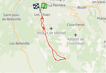

Length
28 km

Max alt
2031 m

Uphill gradient
1140 m
Km-Effort
43 km

Min alt
1114 m

Downhill gradient
1146 m
Boucle
Yes
Creation date :
2021-10-06 08:20:06.823
Updated on :
2021-10-06 12:36:55.808
3h28
Difficulty : Difficult

FREE GPS app for hiking
 SityTrail
IGN / Geographical institutes
SityTrail Plus
The world is yours!
About
Trail Mountain bike of 28 km to be discovered at Auvergne-Rhône-Alpes, Savoy, Les Allues. This trail is proposed by XavierFaidix.
Description
eVTT
Positioning
Country:
France
Region :
Auvergne-Rhône-Alpes
Department/Province :
Savoy
Municipality :
Les Allues
Location:
Unknown
Start:(Dec)
Start:(UTM)
308536 ; 5034148 (32T) N.
Comments